Thursday, June 30, 2016

Basically Virginia So Far - photo


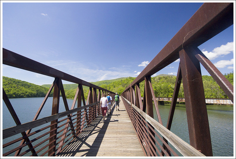
  Red Bull posted this photo on his Instagram today.  He entitled it "Basically Virginia So Far."
It looks like a scene from Lord of the Rings, or a fairy tale.

photo by Red Bull

Crossing the James River


   Red Bull and his pals have hiked to the Johns Hollow Shelter in Glascow, Virginia.  It is mile 786 on the A.T., at an elevation of 1.021 feet.  They hiked 20-22 miles today.

   They crossed the James River on the longest foot bridge on the Appalachian Trail.  Red Bull has fond memories of youth canoe trips on the James River with friends.


photos from vatrailguide.com
James River Foot Bridge


An excerpt from traillink.com:
The James River Foot Bridge carries the Appalachian Trail over the James River in Snowden, Virginia, approximately 20 miles northwest of Lynchburg. The bridge was built on the piers of a demolished CSX bridge that had been replaced with a longer trestle just east of the original bridge, providing a straighter course for freight traffic. Trains pass by frequently against the scenic backdrop of rolling hills and refreshing water below.
When opened in 2000, the James River Foot Bridge eliminated a dangerous crossing of the James River that mixed hikers with vehicular traffic on US 501. A curious note: While this is indeed a footbridge, its name actually refers to Bill Foot, an Appalachian Trail enthusiast who spearheaded the conversion of the bridge into its present use.


Wednesday, June 29, 2016

All is Well


   Red Bull and friends are at the Cornelius Creek Shelter, mile 764.4 on the A.T., with an elevation of 3,114 feet.  We estimate they hiked approximately 15 1/2 miles today.

   It was a brief text to let us know all was well, and his current location.  He is 4 miles away from a shelter closed due to bears, the Thunder Hill Shelter.  Below is an excerpt from The Appalachian Trail Conservancy.


Central Virginia - Thunder Hill Shelter closed due to Problem Bear activity

(5/25/16) Due to repeated problem bear activity the Thunder Hill Shelter (located at mile 769.7 miles north of Springer Mtn) is closed indefinitely. In addition, the Harrison Ground Spring dispersed campsite (mile 772.9), used as an alternate to Thunder Hill Shelter, has been compromised by a problem bear, and is no longer a viable option for camping. Marble Spring dispersed campsite (at mile 776.6) remains viable for camping overnight. 
stock photo
The real bears are not as friendly as Yogi and Boo Boo 


Tuesday, June 28, 2016

Where's Red Bull?


   We have not heard from Red Bull today.  We have projected his location to be around mile 749.1 on the A.T., elevation of 2,228 feet.  This is Buchanan, Virginia with a campground named Middle Creek.  If this is where they stopped, then they would have hiked about 12 miles today.

   Remember the old Where's Waldo books?  Where's Red Bull?

online stock photo

Monday, June 27, 2016

Red Bull Worrying


   Red Bull and his companions are carrying their packs today.  They hiked to the Wilson Creek Shelter on mile 738.7, elevation of 1,854 feet.  They hiked just under 10 miles today.  Hmmm... I think hiking 30 miles took a lot out of them yesterday.

   Red Bull had some questions regarding his finances.  He is looking at the amount he has spent so far, and projecting how much he needs to have in the bank to finish his hike.  He had some valid concerns, and said; "I'll need to cut back on snacks and stuff".  I told him that food was vital to his ability to maintain health and finish the hike, not an area where he should cut back.  I reminded him that he made several expensive purchases (raincoat, hammock/chair), as well as a few nights alone in a hotel when he wanted to quit.  If he is smart with his spending, he should be fine.  He had forgotten about those large expenses and felt relieved.  In his pre-hike planning, he had really only considered the cost of food.  There has been a lot of expense on hostels and occasional hotels.  I do understand the need for showers and the ability to do laundry, but this is adding up very quickly even with shared costs.

   We are glad that Red Bull is looking ahead, and evaluating what he can do to make his resources last through his hike.  He has planned, worked, and saved so much for this dream.  We all feel he has enough savings left to complete his hike.  We told Red Bull as long as he was being wise and sensible with his funds, we would loan him money to complete his hike if necessary.  He could pay us back when he finishes his hike and returns to work.

   Hike on Red Bull, hike on...

photo from offgridsurvival.com


Sunday, June 26, 2016

McAfee Knob - photo


   Red Bull posted this photo on his Instagram today, to me this is a heart stopping photograph.
His father and I both agreed we would not go anywhere near the edge of this rock.
This is McAfee Knob, mile 711.4 on the Appalachian Trail.

photo by a pal of Red Bull
Red Bull giving a "thumbs up" on McAfee Knob

Here is a little information about McAfee Knob from: visitroanokeva.com
McAfee Knob is the most photographed site along the Appalachian Trail which crosses 14 states along its 2,178 mile trail from Georgia to Maine. In Virginia, McAfee Knob is the appalachian trail's poster and postcard image. The hype is supported by the reality. McAfee Knob is the jutting end of a crazily tilted rocky mountain, sticking out into thin air like a diving platform. The view from the Knob sweeps around 270 degrees (everything except through the forest behind), surveying the Catawba Valley and North Mountain to the west, Tinker Cliffs to the north, and the Roanoke Valley to the east. Length:  6 mile round trip (out and back). Difficulty:  Moderately difficult - gradual uphill on the way out and the return is downhill.

Interesting Cloudy View - photo


   Red Bull posted this very interesting cloudy view today on his Instagram.


photo by Red Bull